
Tag: Douglas Water
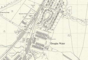
Ordnance Survey map of Ponfeigh Station
mapAn Ordnance Survey map from c. 1950 showing the location of Ponfeigh Station relative to the Douglas Water community. Ponfeigh Railway Station operated between 1864 and 1964 on the Douglas…

Old Photos of Douglas & District
documentA presentation of old photos from Douglas and surrounding areas, compiled by Harvey Black. Use the embedded display below to view this presentation or you can use the controls to…