
")
19th century Carnwath map
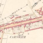
Year: 1858
This was the second map of 1858, showing the whole village of Carnwath. The map indicates three churches in close proximity to each other, including St Mary’s Aisle.
Unless otherwise stated, all text, images, and other media content are protected under copyright. If you wish to share any content featured on Clydesdale's Heritage, please get in touch to request permission.


Area
Tags
Subscribe
Login
0 Comments
Oldest