
Year: 1858
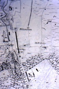
First Ordnance Survey map of Wilsontown
mapOne of the first Ordnance Survey maps of Wilsontown and the surrounding area. The map shows the Iron Works as being disused. Parallel to the old iron works is a…
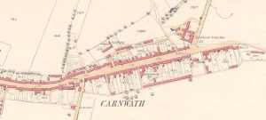
25″ Ordnance Survey map of Carnwath
mapA 25″ Ordnance Survey (OS) map of Carnwath from 1858. The map shows the position of the Lockhart Arms Inn, which is now a farm. The tavern was one of…
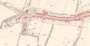
19th century Carnwath map
mapThis was the second map of 1858, showing the whole village of Carnwath. The map indicates three churches in close proximity to each other, including St Mary’s Aisle.

Carnwath 1858 OS Map
mapThis is a very useful map as it shows the position of the Lockhart Arms Inn, now a farm. The tavern was one of the most important in the area.…