
")
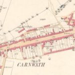
25″ Ordnance Survey map of Carnwath
Year: 1858
A 25″ Ordnance Survey (OS) map of Carnwath from 1858.
The map shows the position of the Lockhart Arms Inn, which is now a farm. The tavern was one of the most important in the area. It also shows the public school opposite.
It is of note that on this map is the Post Office, Market Inn, Commercial Inn, plus several smiddies. The other school was a private school. Gas had arrived in Carnwath by the time this map was created.
Map courtesy of Ordnance Survey
Unless otherwise stated, all text, images, and other media content are protected under copyright. If you wish to share any content featured on Clydesdale's Heritage, please get in touch to request permission.
Area
Tags
Subscribe
Login
0 Comments
Oldest