
_(1596207458)")
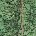
Forest Map of Lesmahagow
Year: 1819
The Forest Map of Lesmahagow from 1819.
The detail of this map is better and more precise than the Ross Map of Lesmahagow from 1773.
The map shows the owners of the principle dwellings, plus the road plans are more accurate.
Map courtesy of the National Library of Scotland.
Unless otherwise stated, all text, images, and other media content are protected under copyright. If you wish to share any content featured on Clydesdale's Heritage, please get in touch to request permission.
Related Content
Area
Tags
Subscribe
Login
0 Comments
Oldest