
")
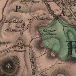
Forest Map of Shieldhill
Year: 1816
The Forest Map of 1816 showing Shieldhill contains considerably more detail than William Roy’s map of 1752. The map indicates the growing importance of neighbouring Huntfield.
The Chancellors had continued to expand their designed landscape with further tree planting.
Map courtesy of the National Library of Scotland.
Unless otherwise stated, all text, images, and other media content are protected under copyright. If you wish to share any content featured on Clydesdale's Heritage, please get in touch to request permission.

Area
Tags
Subscribe
Login
0 Comments
Oldest