
")
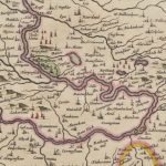
Blaeu map of Leadhills
Year: 1654
Blaeu’s map of Leadhills from 1654.
This map greatly improved accuracy from Timothy Pont’s map of the area. Blaeu was a Dutch cartographer born in Alkmaar. This map was produced in Amsterdam, thus many place names have taken on a rather Dutch interpretation in terms of spelling.
Leadhills is incorrectly spelled as Leadmills on the map.
Map courtesy of the National Library of Scotland.
Unless otherwise stated, all text, images, and other media content are protected under copyright. If you wish to share any content featured on Clydesdale's Heritage, please get in touch to request permission.
Related Content
Area
Tags
Subscribe
Login
0 Comments
Oldest