

Blaeu map of Bonnington
Year: 1654
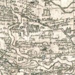
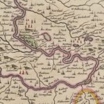
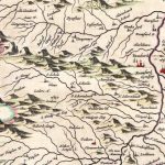
This map was published in 1654 by Joan Blaeu, a Dutch cartographer born in Alkmaar, the son of cartographer Willem Blaeu. It was based on the first detailed map of Lanarkshire created by Timothy Pont (in 1596).
The detail of this map is amazing especially in relation to Bonnington. The fence shown on the map is the Park Pale.
Map reproduced courtesy of the National Library of Scotland.
Unless otherwise stated, all text, images, and other media content are protected under copyright. If you wish to share any content featured on Clydesdale's Heritage, please get in touch to request permission.
Related Content
Area
Tags
Subscribe
Login
0 Comments
Oldest