

Burgh Surveyor’s Map of Lanark
Year: 1913
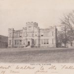
The map is a fascinating glimpse of Lanark just before the outbreak of war in 1914. Interesting features on this map include a plethora of railway lines which include a railway line heading south which connected Lanark with Ayr. It also includes the Bonnington Electric Laundry out by Lanark Golf Course, The Lanark Poor House and Smyllum House which was used a Catholic Orphanage.
Since it is obviously based on an Ordnance Map, it is reproduced with the courtesy of the Ordnance Survey Division.
Unless otherwise stated, all text, images, and other media content are protected under copyright. If you wish to share any content featured on Clydesdale's Heritage, please get in touch to request permission.
Related Content

Area
Tags
Subscribe
Login
0 Comments
Oldest