

Forest Map
Year: 1819
A Forest Map from 1819.
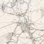
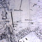
This is the first detailed map of Lanarkshire to show the Wilsontown Iron Works. It even shows the furnace and a rail road that went in the direction of Climpy for coal and limestone. The iron tended to come from the direction of Mountain Blaw, which is shown at the top right hand corner of the map.
Finally, Wilsontown House is shown on the map as well as Cleugh House. Both houses were the homes of the Wilson brothers.
Unless otherwise stated, all text, images, and other media content are protected under copyright. If you wish to share any content featured on Clydesdale's Heritage, please get in touch to request permission.
Area
Tags
Subscribe
Login
0 Comments
Oldest