

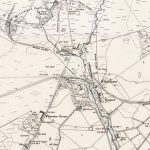
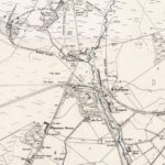
First Ordnance Survey map of Wilsontown
Year: 1858
One of the first Ordnance Survey maps of Wilsontown and the surrounding area. The map shows the Iron Works as being disused. Parallel to the old iron works is a row of houses known as Quality Row. These dwellings were erected by the Dixons to provide accommodation for those working in the local coal mines. Similar houses were erected at Rootpark.
Unless otherwise stated, all text, images, and other media content are protected under copyright. If you wish to share any content featured on Clydesdale's Heritage, please get in touch to request permission.

Area
Tags
Subscribe
Login
0 Comments
Oldest