

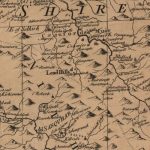
General Roy Map
Year: 1750
This map, completed in the 1750s by General Roy was part of a series completed across Scotland. Wilsontown does not exist at this time. The hamlets of East Forth, West Forth, and Mid Forth are shown.
Unless otherwise stated, all text, images, and other media content are protected under copyright. If you wish to share any content featured on Clydesdale's Heritage, please get in touch to request permission.
Area
Tags
Subscribe
Login
0 Comments
Oldest