
")
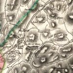
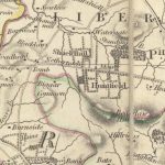
Thomson Map of Lesmahagow
Year: 1832
The Thomson Map of Lesmahagow from 1832.
The map shows interesting features such as Goldrig, a castle in ruines near Dumbraxhill, and other interesting features such as lint mills and lime works.
John Thomson (1777-c1840) was a Scottish cartographer from Edinburgh, celebrated for his 1817 New General Atlas.
Map courtesy of the National Library of Scotland.
Unless otherwise stated, all text, images, and other media content are protected under copyright. If you wish to share any content featured on Clydesdale's Heritage, please get in touch to request permission.

Area
Tags
Subscribe
Login
0 Comments
Oldest