")
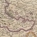
William Roy map of Carstairs
Year: 1750
The William Roy map shows the village of Carstairs with properties marked out. Of much interest is Carstairs House, which was – at this point – still occupied by the Lockharts and was then referred to as Lockharthall. Notice the fine designed landscape created by the Lockharts.
This map dates from around 1750.
William Roy was a Scottish military engineer, surveyor, and antiquarian. He was an innovator who applied new scientific discoveries and newly emerging technologies to the accurate mapping of Great Britain. His masterpiece is usually referred to as Roy’s Map of Scotland. It was Roy’s advocacy and leadership that led to the creation of the Ordnance Survey in 1791, the year after his death.
Map courtesy of the British Library.
Unless otherwise stated, all text, images, and other media content are protected under copyright. If you wish to share any content featured on Clydesdale's Heritage, please get in touch to request permission.