Year: 1752
Roy Map of Quothquan and Shieldhill
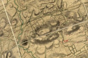
mapWilliam Roy’s 1752 map of Quothquan and Shieldhill, showing that the area around Shieldhill had several fields surrounded by trees, part of a designated landscape. Quothquan Mill is shown to…
More results...

William Roy’s 1752 map of Quothquan and Shieldhill, showing that the area around Shieldhill had several fields surrounded by trees, part of a designated landscape. Quothquan Mill is shown to…