
")
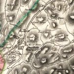
Arrowsmith map of Leadhills
Year: 1807
The Aaron Arrowsmith Map of 1807 is a useful map. It was undertaken at a time when there was a significant demand for lead. In 1807 Britain was engaged in the Napoleonic Wars.
The map is also interesting in that it shows the site both of the Gold Scours and a slate quarry.
Aaron Arrowsmith (1750–1823) was an English cartographer, engraver and publisher and founding member of the Arrowsmith family of geographers.
Map courtesy of the National Library of Scotland.
Unless otherwise stated, all text, images, and other media content are protected under copyright. If you wish to share any content featured on Clydesdale's Heritage, please get in touch to request permission.
Area
Tags
Subscribe
Login
0 Comments
Oldest