
")
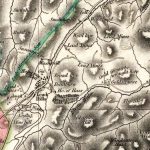
First Edition Ordnance Survey map of Leadhills
Year: 1859
This is the first Ordnance Survey map of Leadhills from 1859. The OS maps were a game-changer in the field of cartography.
From this map, we see that many of the mines had fallen into disuse. Lead mining, from this period, had begun to decline. The map also shows the magazine for black powder for blasting, the bell used for ringing the alarm, and the old library (the library is the oldest subscription library in Scotland).
Unless otherwise stated, all text, images, and other media content are protected under copyright. If you wish to share any content featured on Clydesdale's Heritage, please get in touch to request permission.
Area
Tags
Subscribe
Login
0 Comments
Oldest