

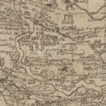
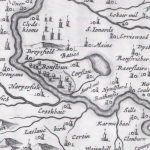
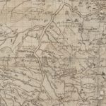
Pont Map of Lanark
Year: 1596
A Timothy Pont map from 1596 showing Lanark. The map shows what appears to be a tower house enclosed by a ditch. This ditch could be the remains of the Park Pale. The word Pale means stake, coming from the Latin Palus, a stake. The purpose of a Pale enclosure was to keep deer in an area for hunting. The Pale was an earth bank with a high wooden fence to stop the deer escaping. Several years ago, the remains of the Pale were found during a walk near the Falls.
Unless otherwise stated, all text, images, and other media content are protected under copyright. If you wish to share any content featured on Clydesdale's Heritage, please get in touch to request permission.
Related Content
Area
Tags
Subscribe
Login
0 Comments
Oldest