
")
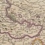
Lampits Ferry
Year: 1864
This map of c.1864 shows the position of the Lampits Ferry and how Smiths Bakers van would get to Pettinain. The map also shows the Village of Pettinain, which was in the 12th century a grange of the monastery of Dryburgh.
Further over is Westraw, originally a dower house of the Carmichael family dating back to the 18th century, though parts of it date back to the 17th century.
Map courtesy of the National Library of Scotland.
Unless otherwise stated, all text, images, and other media content are protected under copyright. If you wish to share any content featured on Clydesdale's Heritage, please get in touch to request permission.

Area
Tags
Subscribe
Login
0 Comments
Oldest