
")
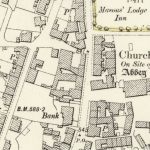
First Ordnance Survey map of Lesmahagow
Year: 1864
The first Ordnance Survey 6″ to 1 mile map of the Lesmahagow area shows a major change in map making. By 1864, the detail included in the maps is considerable.
The map shows the Monastic Lade or water channel running into the Nethan near Turfholm Bridge. St. Foxes Castle is a puzzling earthwork whose setting was disturbed by the railway coming into Lesmahagow.
Map courtesy of the National Library of Scotland.
Unless otherwise stated, all text, images, and other media content are protected under copyright. If you wish to share any content featured on Clydesdale's Heritage, please get in touch to request permission.
Related Content
Area
Tags
Subscribe
Login
0 Comments
Oldest