
")
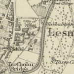
Ordnance Survey map of Lesmahagow
Year: 1896
An example of a 25″ to 1 mile map of Lesmahagow completed in 1896 for the Ordnance Survey.
Interesting notes include the Gas Works located next to the graveyard. The Commercial Hotel next to the Parish Church is not marked on the map, though you can see the lade shown in blue.
Map courtesy of the National Library of Scotland.
Unless otherwise stated, all text, images, and other media content are protected under copyright. If you wish to share any content featured on Clydesdale's Heritage, please get in touch to request permission.
Area
Tags
Subscribe
Login
0 Comments
Oldest