

Wilsontown 25 Inch Map
Year: 1832
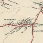
The 25 inch map, which was Thomson’s Map of 1832, shows the Wilsontown area prior to the arrival of the railway. The rail road mentioned on the map was a horse drawn road to bring the coal from the pits beyond Muirlaw. Points of interest include the iron mine, coal mines, and limestone pits.
Unless otherwise stated, all text, images, and other media content are protected under copyright. If you wish to share any content featured on Clydesdale's Heritage, please get in touch to request permission.


Area
Tags
Subscribe
Login
0 Comments
Oldest