
")
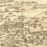
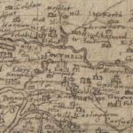
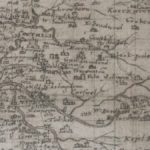
Pont Map of Carnwath
Year: 1596
An amazingly detailed map of the Carnwath area by cartographer Timothy Pont in c. 1596. It is fascinating to see both a West and East Kilncadzow mentioned.
Map courtesy of the National Library of Scotland.
Unless otherwise stated, all text, images, and other media content are protected under copyright. If you wish to share any content featured on Clydesdale's Heritage, please get in touch to request permission.
Related Content
Area
Tags
Subscribe
Login
0 Comments
Oldest