
")
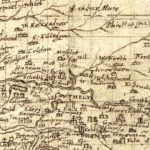
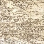
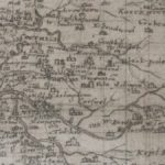
Pont map of Carnwath
Year: 1596
This is the Timothy Pont map of Carnwath from 1596. It later formed the basis of the map created by Joan Blaeu of the Netherlands.
The map does not mention Carnwath, instead featuring Couthally (spelled, in this instance, as ‘Couthely’). This area was the centre of the Dalzell estates in the area. By this time, the Sommervilles had moved to Ampherlaw.
Unless otherwise stated, all text, images, and other media content are protected under copyright. If you wish to share any content featured on Clydesdale's Heritage, please get in touch to request permission.
Related Content
Area
Tags
Subscribe
Login
0 Comments
Oldest