")
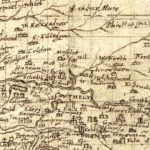
Pont Map of Crawford
Year: 1596
The castle at Crawford, shown in this map from c. 1596, made a great impression on the cartographer, Timothy Pont. The castle had been owned by the Lindsay family since around 1488. It is also of note to see the Church of St. Constantine was away from the castle by some distance. The ruins of this church lie about halfway between Crawford and Abington (marked by a cross on the map).
Rev Timothy Pont (c. 1560–c.1627) was a Scottish minister, cartographer and topographer. He was the first to produce a detailed map of Scotland. Pont’s maps are among the earliest surviving to show a European country in minute detail, from an actual survey.
Map courtesy of the National Library of Scotland.
Unless otherwise stated, all text, images, and other media content are protected under copyright. If you wish to share any content featured on Clydesdale's Heritage, please get in touch to request permission.