")
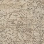
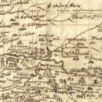
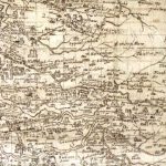
Pont Map of Leadhills area
Year: 1596
In 1596, when this map was produced, lead mining had not commenced in the area. As such, the map shows a number of small settlements such as Glendorch and Snar. Here, small bastle (fortified farm houses) were built. The owners eked out a meagre living from sheep farming. Some, however, did try to make their fortune out of gold.
Rev Timothy Pont (c. 1560–c.1627) was a Scottish minister, cartographer and topographer. He was the first to produce a detailed map of Scotland. Pont’s maps are among the earliest surviving to show a European country in minute detail, from an actual survey.
Map courtesy of the National Library of Scotland.
Unless otherwise stated, all text, images, and other media content are protected under copyright. If you wish to share any content featured on Clydesdale's Heritage, please get in touch to request permission.