
![]()
Welcome to Clydesdale's Heritage, a project aimed at encouraging all people to take an active interest in the heritage and history of the Clydesdale area.
This website is one of several initiatives from Lanark and District Archaeology Society (LADAS) to encourage engagement with the history of the region.
The project includes lecture programmes, fieldwalks, cataloguing artefacts, inspiring school pupils during talks and presentations, and working with like-minded organisations – with the end goal being to record and preserve the heritage of Clydesdale.
Most popular this month
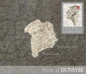
Parish of Dunsyre
mapincluding the village of Dunsyre. MAP & INDEX of all parishes. DUNSYRE, village and parish in upper ward of Lanarkshire. The village stands 6½ miles east of Carnwath, and has…
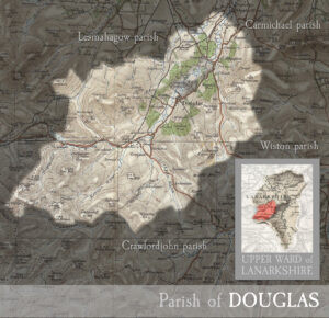
Parish of Douglas
mapincluding the town of Douglas and the village of Glespin and part of Rigside. MAP & INDEX of all parishes. DOUGLAS, river, town, castle, and parish in upper ward of…
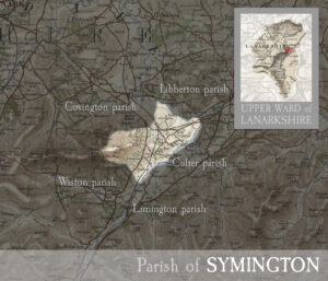
Parish of Symington
mapincluding the village of Symington. MAP & INDEX of all parishes. SYMINGTON, village and parish in upper ward of Lanarkshire. The village stands adjacent to the Clyde, 7 miles south-east…
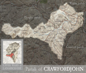
Parish of Crawfordjohn
mapincluding the villages of Abington and Crawfordjohn MAP & INDEX of all parishes. CRAWFORDJOHN, village and parish in upper ward of Lanarkshire. The village stands on Duncaton rivulet, 3¾ miles…
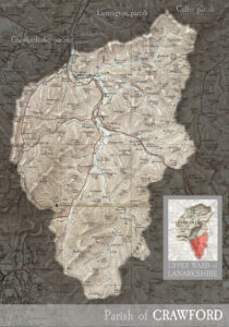
Parish of Crawford
mapincluding the villages of Crawford and Leadhills. MAP & INDEX of all parishes. CRAWFORD, village and parish in southern extremity of Lanarkshire. The village stands on the Clyde, 2 miles…

Parish of Lesmahagow
mapincluding the town of Lesmahagow, and the villages of Auchenheath, Blackwood, Boghead, Coalburn, Crossford, Hazelbank, Kirkfieldbank, Kirkmuirhill, New Trow, and Turfholm. MAP & INDEX of all parishes. LESMAHAGOW, town and…
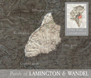
Parish of Lamington & Wandel
mapincluding the villages of Lamington and Wandel. MAP & INDEX of all parishes. LAMINGTON, village and parish in upper ward of Lanarkshire. The village stands on burn of its own…
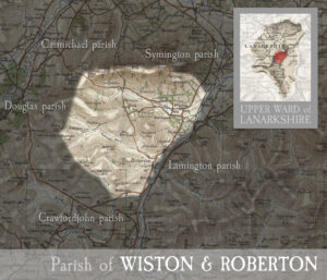
Parish of Wiston & Roberton
mapincluding the villages of Wiston and Roberton. MAP & INDEX of all parishes. WISTON, village and parish in upper ward of Lanarkshire. The village stands about a mile west-north-west of…
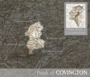
Parish of Covington
mapincluding the villages of Covington and Thankerton. MAP & INDEX of all parishes. COVINGTON, village and parish in upper ward of Lanarkshire. The village stands about 1¼ mile north of…
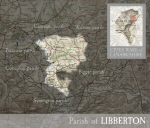
Parish of Libberton
mapincluding the villages of Libberton and Quothquan. MAP & INDEX of all parishes. LIBBERTON, hamlet and parish in upper ward of Lanarkshire. The hamlet lies 2½ miles south-east of Carnwath,…
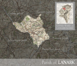
Parish of Lanark
mapincluding the Royal Burgh of Lanark and the villages of Cartland, Cleghorn, Hyndfordbridge, Nemphlar, and New Lanark. MAP & INDEX of all parishes. LANARK, town and parish in upper ward…
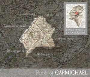
Parish of Carmichael
mapincluding the villages of Carmichael, Douglas Water, Ponfeigh, and parts of Rigside. MAP & INDEX of all parishes. CARMICHAEL, parish in upper ward of Lanarkshire. Its post town in Thankerton.…