
Tag: Quothquan
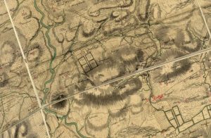
Roy Map of Quothquan and Shieldhill
mapWilliam Roy’s 1752 map of Quothquan and Shieldhill, showing that the area around Shieldhill had several fields surrounded by trees, part of a designated landscape. Quothquan Mill is shown to…
Blaeu map of Quothquan
mapThe 1654 map of Quothquan by Joan Blaeu. The map does not indicate a settlement at Quothquan, instead showing Quothquan Mill (then named ‘Kothoon Mill’). This was shown at a…

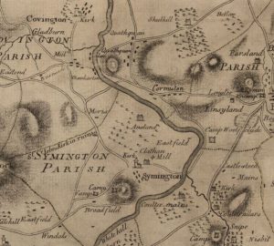
Ross Map of Quothquan
mapThe Ross Map of Quothquan from 1773. The map shows clearly the settlement of Quothquan stretching alongside a road from Roadhead Farm. The church is not marked on this map;…
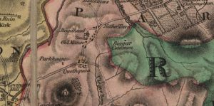
Forest Map of Quothquan
mapThe Forest Map of Quothquan from 1816. This map shows Roadhead as a farm, and also shows that the Manse lay in a field to the west of the ruins…