
Carnwath
Carnwath has an interesting history going back to the Medieval period when the motte was built by the Sommerville family who came to the area in the twelfth century. This still exists today as a feature in Carnwath Golf course. Field-walking and metal detecting in the area around the Motte have resulted in the recovery of both pottery and coins from the 12th and 13th centuries; the coins being silver pennies of Edward I.
The Sommerville family were also responsible for building a church across the road from the Motte; much of the original Medieval church has disappeared. What is left is the St Mary’s Ailse, which was constructed in 1424. The style of the ailse is similar to the church of Corstophine on the outskirts of Edinburgh and is typical of the Perpendicular style of architecture which was common in England at that time. In the the Ailse there are several monuments to members of the Sommerville family, the Dalzells, and the Lockharts. In the churchyard there many interesting gravestones including one of a knight and a memorial to some of the martyrs of the Covenanting era.
Carnwath had a Medieval tolbooth till the 1930s when it was demolished. This building went back to the early part of the sixteenth century at a time when the famous Red Hose Race started. It began in 1508 and is reputed to be the oldest foot race in Scotland. The tradition was that the local laird had to give a pair of stockings (hose) as a prize or forfeit his lands.
Although Carnwath lost its tolbooth, the records of the barony court of the Burgh of Carnwath survive and were published by the Scottish Record Society; these cover the period of the 1530s–1540s and give a fascinating insight into the story of the farming community in Carnwath and its surroundings
Narrow by year:
Narrow by tags:

Somerville Motte, Carnwath
articleRecent news about celebrations in connection with the Somerville family have led me to add this article. The early history of the Somerville family Coming to Carnwath from the West…
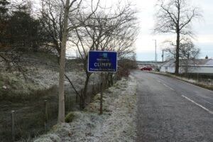
Climpy Lime Works
articleAn Early Industry and a Beautiful Bing. The road from Forth to Climpy winds its way across a windswept moorland landscape that bears the scars of a long history of…
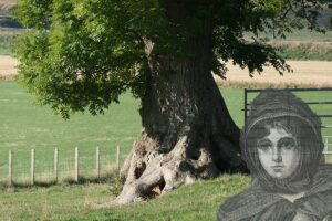
The Haunted Ash of Lampits
articleThe Carnwath correspondent of the Hamilton Advertiser seems to have had an unusual interest in all things uncanny and supernatural. The weekly column of village news reported the usual mix…
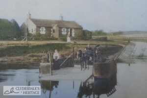
The Lampits Float
article“Out of Date and Inadvisable from any Standpoint” A little ferry boat once plied the Clyde between the parishes of Pettinain and Carnwath. The source of all manner of adventures…
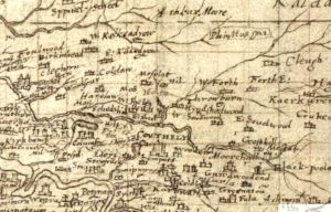
Pont map of Couthally
mapPont’s 1596 map of Couthally. Couthally Castle, near Carnwath, was more important than Carnwath as it was then the home of the Sommerville’s. Later, the estate passed into the hands…
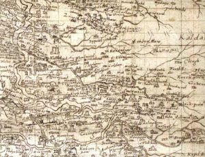
Pont Map of Carnwath
mapAn amazingly detailed map of the Carnwath area by cartographer Timothy Pont in c. 1596. It is fascinating to see both a West and East Kilncadzow mentioned. Map courtesy of…
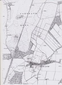
Ordnance Survey map of Carnwath
mapOne of the first Ordnance Survey maps of Carnwath, from c. 1860. Several interesting features are included, such as the Lockhart Arms Hotel, which is now a farm. The original…
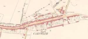
25″ Ordnance Survey map of Carnwath
mapA 25″ Ordnance Survey (OS) map of Carnwath from 1858. The map shows the position of the Lockhart Arms Inn, which is now a farm. The tavern was one of…
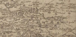
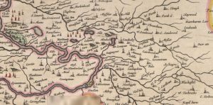
Pont map of Carnwath
mapThis is the Timothy Pont map of Carnwath from 1596. It later formed the basis of the map created by Joan Blaeu of the Netherlands. The map does not mention…
Blaeu map of Couthally
mapA map of Carnwath (Couthally) by Joan Blaeu in 1645. Blaeu was a Dutch cartographer born in Alkmaar, the son of cartographer Willem Blaeu. Couthally rather than Carnwath is mentioned.…